meta data for this page
This is an old revision of the document!
LoKe (Locate Earth Quakes)
Group 11 –
- Deepak Man Shrestha, c0346857
- Kamal Panthi, c046747
- Santosh Kalwar, b0331927
LoKe is an application which is focused to find the location of Earthquake hit areas through Google map. This is a mobile application developed in ANDROID and aims to provide the detail information about the earthquake around the world to the users.
Idea
To identify the location and information about ”earthquakes” hit areas around the world.
In 2010 only, there were more than ten earthquakes around the world. Two of the biggest earthquake hit areas were Haiti and Chile, which we learned in the News & Media. However, Our primary target is not to predict the earthquake but to find locations & casualties information, where earthquake has been hit.
Today in this internet world, there are many sources from where we can get the information about earthquakes. However getting informations along with its location in Globe Map can be more illustrating. So we came up with the idea to develop an application using Google map that provide location and information about the earthquake around the world. Such information can be input by a user.So the information about the earthquake is based upon the user input.
This application is useful for any kind of user who wants to have more in depth knowledge about earthquake hit area around the world with reference to Map.
Features & Mission
1 = most critical or core feature .. 5 = least critical or core feature
| S/N | Feature | Priority | Mission |
|---|---|---|---|
| 1 | To retrieve the exact location coordinates by clicking the respective location on Google map | 1 | Accomplished |
| 2 | To input the disaster information through Map | 1 | Accomplished |
| 3 | To create Database and Table through SQLlite | 1 | Accomplished |
| 4 | To store and retrieve data from table | 1 | Accomplished |
| 5 | To get location and description about earthquake through database and populate in Google Map | 1 | Accomplished |
| 6 | Show the location by putting flag on Map | 1 | Accomplished |
| 7 | Can have different view in Map( Map or Satelite) | 2 | Accomplished |
| 8 | To implement different layouts | 3 | Accomplished |
| 9 | To share the information about earthquakes on social-networks | 4 | Ongoing…limited time |
| 10 | To predict the earthquake information based on different sets of data | 5 | Future work…(Needs couple of years of extensive research) |
| 11 | To develop a system for collaborative environment to predict next earthquake happenings around the world | 5 | Future work…(Needs large research funding) |
| 12 | To create user management for 'personalized earthquake hit areas' | 5 | Future work… (Needs time, energy and money) |
Major Goals
- Develop an application that includes overlay in Google Maps.
- Provide information about severity of quake via, casualties, magnitude, location of the earthquakes.
Environments
- Android 2.1
- Google SDK
- Eclipse
Challenges
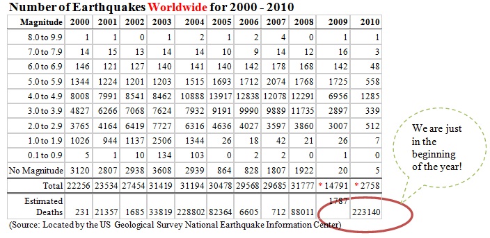
LoKe (Locate Earthquakes) is unique idea developed one months before the start of codecamp. See the picture below:
So,
We came up with idea that,
How about some kind of system using Android + Google Maps to locate the earthquakes around the globe?
We can save people by reporting 'various informations' on earthquakes. The 'various information' includes but are not limited to:
- Number of casualties.
- On ways to volunteer and provide help.
- Based on news and media, user can put the information.
- User can also make 'personalized earthquake hit areas' & share among friends or family using social networks.
- Any information about 'Natural Disasters' is very significant which can save a life.
Design
Screen shots
(when ready)
Implementation Comments
Presentation
Package
(.zip file)
How to run
Conclusion of your work
(what was good, what was bad, impressive or depressive things in android development)
